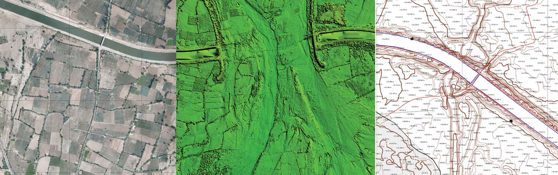
| Description | AerologixMaps - Business Version | Photogrammetry software solution for land surveying professionals. 3D mapping & modelling. Fly a drone, generate point clouds, orthophotos, survey maps. |
Standard Outputs:
- UAV Raw Image Processing
- Ortho Mosaic
- GCP based reports
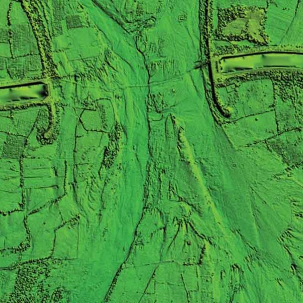
- DSM
- DTM
- Point Cloud
- 3D Mesh
- Contour
Advance outputs:
- Feature Extraction
- Base Map Preparation
- Digitization
- Superimposition of Layouts
- L-section and X- Section generation at any interval
- ROW Analysis
- Cut Fill analysis
- Benching Volume
- Tin Modelling
- Grid Elevation Models
| geocloud.work enables you to work online with a variety of software products – Metashape (Agisoft), 3Dsurvey, CATALYST (PCI Geomatics), Photomod (Racurs), Topocad, Hydromagic, nanoCAD, progeCAD, QGIS, Panorama GIS, Cloud Compare and much more.
Price is per hour.
| Hydromagic is a professional hydrographic survey package, which can be used to map depth areas using an echo sounder and GNSS receiver. | nanoCAD is a professional-grade CAD platform fully compatible with the industry’s DWG standard. It offers the standard user interface with a wide set of tools for 2D/3D drafting that can be extended with modules specific to the needs of professionals in engineering, architecture, and construction. |
| Content | AerologixMaps - is an end to end cloud based aerial image data processing solution, with Cost Leadership market approach.
Process aerial image data in easiest way possible and in most affordable price. Signup for limited period offer today. | Photogrammetry software solution for land surveying professionals. 3D mapping & modelling. Fly a drone, generate point clouds, orthophotos, survey maps.
We help people in the field do their job faster and easier. With real-life experience at the heart of our software, we help professionals do today what they couldn’t do yesterday.
Our software is constantly evolving. What started as a tool created by surveyors for surveyors, has turned into an agile solution that solves problems for many industries – from construction workers to first responder. | With the growing need for drone-based professional data processing and analytical solutions with advanced features. No need to worry about buying expensive licenses and top-notch hardware.
Henceforth, we would like to extend our services for collaboration of any project size from small to large scale. I strongly believe that our collaboration would hugely benefit both our establishment maintaining complete confidentiality, which would culminate in providing superior output and higher satisfaction services to our clients. Assure you – our cost-effectiveness services and solutions will reduce both your time and in-house working cost beyond 25% – 30% and within the anticipated timeline.
Aerizone Advantage:
- Accurate results.
- Timely Delivery.
- Industry-standard formats and outputs.
- Flexible charges as per projects.
| UNIVERSAL CLOUD-BASED PLATFORM FOR 3rd PARTY DESKTOP SOFTWARE.
Customers: the geocloud.work platform provides an instant remote access to licensed software products in a variety of domains. Customers can work with ready-for-use preinstalled software products on a Pay-per-Use or a Period Subscription basis. No software download and installation are required.
Software vendors: the geocloud.work is a universal cloud platform for desktop software. GeoCloud can bring your regular desktop (Windows or Linux) software to customers worldwide for immediate online use. A software vendor can start hosting their software at GeoCloud in as little as one hour. This simplicity makes GeoCloud an attractive alternative to redesigning your application from scratch for the cloud. Licensing of the GeoCloud platform for "white-label" use on your site is also available.
Marketplace: the geocloud.work connecting Employers and Contractors. Our contractors are experienced in working with a variety of geospatial software – Metashape (Agisoft), 3Dsurvey, CATALYST (PCI Geomatics), Photomod (Racurs), Topocad, Hydromagic, nanoCAD, progeCAD, QGIS, Panorama GIS, Cloud Compare and much more.
Geocloud.work also provides powerful self-service Windows or Linux based computers and unlimited storage enabling software installation and work with it. Customers and Software vendors can install their software on the computers and work with it worldwide. They can share this software with friends, colleagues and their customers. | Hydromagic is a professional hydrographic survey package, which can be used to map depth areas using an echo sounder and GNSS receiver.
The software is very affordable, and the learning curve is very short. You can start creating your first sounding within a single day. Our website contains a lot of free training material so you will be able to learn the software without expensive courses.
| nanoCAD is a professional-grade CAD platform fully compatible with the industry’s DWG standard. It offers the standard user interface with a wide set of tools for 2D/3D drafting that can be extended with modules specific to the needs of professionals in engineering, architecture, and construction.
|