| Description | AerologixMaps - Business Version | CATALYST Professional (PCI Geomatics, Canada) is the world’s leading geospatial desktop suite, specializing in Remote Sensing, Photogrammetry & Earth Observation Science for optical, and SAR imagery. Easily integrate this powerful image analysis, ortho-mosaicking, and image processing capabilities into your geospatial technology workflow. | PHOTOMOD provides a closed photogrammetric production cycle and involves the creation of the following products: digital maps, DTMs, orthomosaics, 3D vectors, 3D Models and Radar mapping. The PHOTOMOD software package is used in all areas where metric information about the Earth is required with maximum accuracy.
| AerologixMaps is an end to end cloud based Aerial Image Data processing solution. Making Maps easy & affordable. AMaps USP are low cost, User friendliness - Process your data in just a few clicks , High quality outputs, Elimination of expensive hardware. Download is not mandatory to share maps with clients. | Photogrammetry software solution for land surveying professionals. 3D mapping & modelling. Fly a drone, generate point clouds, orthophotos, survey maps. | geocloud.work enables you to work online with a variety of software products – Metashape (Agisoft), 3Dsurvey, CATALYST (PCI Geomatics), Photomod (Racurs), Topocad, Hydromagic, nanoCAD, progeCAD, QGIS, Panorama GIS, Cloud Compare and much more.
Price is per hour.
|
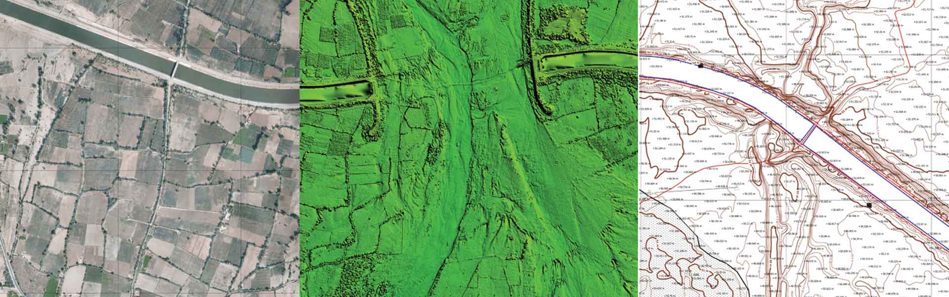
| Content | AerologixMaps - is an end to end cloud based aerial image data processing solution, with Cost Leadership market approach.
Process aerial image data in easiest way possible and in most affordable price. Signup for limited period offer today. | CATALYST Professional (PCI Geomatics, Canada) is the world’s leading geospatial desktop suite, specializing in Remote Sensing, Photogrammetry & Earth Observation Science for optical, and SAR imagery. Easily integrate this powerful image analysis, ortho-mosaicking, and image processing capabilities into your geospatial technology workflow.
| PHOTOMOD provides a closed photogrammetric production cycle and involves the creation of the following products: digital maps, DTMs, orthomosaics, 3D vectors, 3D Models and Radar mapping. The PHOTOMOD software package is used in all areas where metric information about the Earth is required with maximum accuracy.
| Downloadable Data --
- Digital Model - 3D Model, DSM, DTM, SDSM
- Level Curves
- Point Cloud - DENSE, SIMPLIFIED
- Orthomosaic & Ortho lite
- Contour Line - IFV Grey Scale, Vari-Greyscale.
- Reports
Features ---
- High end Data protection
- Direct Output sharing with clients
- User centric design & workflow
- Affordability
- Prompt assistance assured.
- GCP Integration.
| Photogrammetry software solution for land surveying professionals. 3D mapping & modelling. Fly a drone, generate point clouds, orthophotos, survey maps.
We help people in the field do their job faster and easier. With real-life experience at the heart of our software, we help professionals do today what they couldn’t do yesterday.
Our software is constantly evolving. What started as a tool created by surveyors for surveyors, has turned into an agile solution that solves problems for many industries – from construction workers to first responder. | UNIVERSAL CLOUD-BASED PLATFORM FOR 3rd PARTY DESKTOP SOFTWARE.
Customers: the geocloud.work platform provides an instant remote access to licensed software products in a variety of domains. Customers can work with ready-for-use preinstalled software products on a Pay-per-Use or a Period Subscription basis. No software download and installation are required.
Software vendors: the geocloud.work is a universal cloud platform for desktop software. GeoCloud can bring your regular desktop (Windows or Linux) software to customers worldwide for immediate online use. A software vendor can start hosting their software at GeoCloud in as little as one hour. This simplicity makes GeoCloud an attractive alternative to redesigning your application from scratch for the cloud. Licensing of the GeoCloud platform for "white-label" use on your site is also available.
Marketplace: the geocloud.work connecting Employers and Contractors. Our contractors are experienced in working with a variety of geospatial software – Metashape (Agisoft), 3Dsurvey, CATALYST (PCI Geomatics), Photomod (Racurs), Topocad, Hydromagic, nanoCAD, progeCAD, QGIS, Panorama GIS, Cloud Compare and much more.
Geocloud.work also provides powerful self-service Windows or Linux based computers and unlimited storage enabling software installation and work with it. Customers and Software vendors can install their software on the computers and work with it worldwide. They can share this software with friends, colleagues and their customers. |