| Description | CATALYST Professional (PCI Geomatics, Canada) is the world’s leading geospatial desktop suite, specializing in Remote Sensing, Photogrammetry & Earth Observation Science for optical, and SAR imagery. Easily integrate this powerful image analysis, ortho-mosaicking, and image processing capabilities into your geospatial technology workflow. |
Standard Outputs:
- UAV Raw Image Processing
- Ortho Mosaic
- GCP based reports
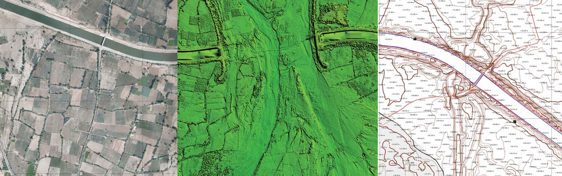
- DSM
- DTM
- Point Cloud
- 3D Mesh
- Contour
Advance outputs:
- Feature Extraction
- Base Map Preparation
- Digitization
- Superimposition of Layouts
- L-section and X- Section generation at any interval
- ROW Analysis
- Cut Fill analysis
- Benching Volume
- Tin Modelling
- Grid Elevation Models
| Photogrammetry software solution for land surveying professionals. 3D mapping & modelling. Fly a drone, generate point clouds, orthophotos, survey maps. | PHOTOMOD provides a closed photogrammetric production cycle and involves the creation of the following products: digital maps, DTMs, orthomosaics, 3D vectors, 3D Models and Radar mapping. The PHOTOMOD software package is used in all areas where metric information about the Earth is required with maximum accuracy.
| nanoCAD is a professional-grade CAD platform fully compatible with the industry’s DWG standard. It offers the standard user interface with a wide set of tools for 2D/3D drafting that can be extended with modules specific to the needs of professionals in engineering, architecture, and construction. | Photogrammetric processing and 3D models generation. Price is per hour. |
| Content | CATALYST Professional (PCI Geomatics, Canada) is the world’s leading geospatial desktop suite, specializing in Remote Sensing, Photogrammetry & Earth Observation Science for optical, and SAR imagery. Easily integrate this powerful image analysis, ortho-mosaicking, and image processing capabilities into your geospatial technology workflow.
| With the growing need for drone-based professional data processing and analytical solutions with advanced features. No need to worry about buying expensive licenses and top-notch hardware.
Henceforth, we would like to extend our services for collaboration of any project size from small to large scale. I strongly believe that our collaboration would hugely benefit both our establishment maintaining complete confidentiality, which would culminate in providing superior output and higher satisfaction services to our clients. Assure you – our cost-effectiveness services and solutions will reduce both your time and in-house working cost beyond 25% – 30% and within the anticipated timeline.
Aerizone Advantage:
- Accurate results.
- Timely Delivery.
- Industry-standard formats and outputs.
- Flexible charges as per projects.
| Photogrammetry software solution for land surveying professionals. 3D mapping & modelling. Fly a drone, generate point clouds, orthophotos, survey maps.
We help people in the field do their job faster and easier. With real-life experience at the heart of our software, we help professionals do today what they couldn’t do yesterday.
Our software is constantly evolving. What started as a tool created by surveyors for surveyors, has turned into an agile solution that solves problems for many industries – from construction workers to first responder. | PHOTOMOD provides a closed photogrammetric production cycle and involves the creation of the following products: digital maps, DTMs, orthomosaics, 3D vectors, 3D Models and Radar mapping. The PHOTOMOD software package is used in all areas where metric information about the Earth is required with maximum accuracy.
| nanoCAD is a professional-grade CAD platform fully compatible with the industry’s DWG standard. It offers the standard user interface with a wide set of tools for 2D/3D drafting that can be extended with modules specific to the needs of professionals in engineering, architecture, and construction.
| Agisoft Metashape is a stand-alone software product that performs photogrammetric processing of digital images and generates 3D spatial data to be used in GIS applications, cultural heritage documentation, and visual effects production as well as for indirect measurements of objects of various scales.
|