-

3Dsurvey at www.geocloud.work
₹400.00Photogrammetry software solution for land surveying professionals. 3D mapping & modelling. Fly a drone, generate point clouds, orthophotos, survey maps.
-
-44%
AerologixMaps – Pro Version
₹7,000.00One time offer – at no match price.
AerologixMaps is an end to end cloud based Aerial Image Data processing solution. Making Maps easy & affordable. AMaps USPs are Low cost, User friendly – data processing in just a few clicks , High quality outputs, Elimination of expensive hardware. Share maps directly with clients without downloading.
-
Agisoft Metashape at www.geocloud.work
₹245.00Photogrammetric processing and 3D models generation. Price is per hour.
-
-47%

AMaps – Business Version — One time offer at no match Price.
₹16,000.00AerologixMaps – Business Version
-
-59%
AMaps – Lite One time offer at no match Price.
₹2,000.00AerologixMaps is an end to end cloud based Aerial Image Data processing solution. Making Maps easy & affordable. AMaps USP are low cost, User friendliness – Process your data in just a few clicks , High quality outputs, Elimination of expensive hardware. Download is not mandatory to share maps with clients.
-
CATALYST (PCI Geomatic) at www.geocloud.work
₹296.00CATALYST Professional (PCI Geomatics, Canada) is the world’s leading geospatial desktop suite, specializing in Remote Sensing, Photogrammetry & Earth Observation Science for optical, and SAR imagery. Easily integrate this powerful image analysis, ortho-mosaicking, and image processing capabilities into your geospatial technology workflow.
-
Hydromagic at www.geocloud.work
₹230.00Hydromagic is a professional hydrographic survey package, which can be used to map depth areas using an echo sounder and GNSS receiver.
-

nanaCAD at www.geocloud.work
₹210.00nanoCAD is a professional-grade CAD platform fully compatible with the industry’s DWG standard. It offers the standard user interface with a wide set of tools for 2D/3D drafting that can be extended with modules specific to the needs of professionals in engineering, architecture, and construction.
-
Photomod Racurs at www.geocloud.work
₹177.00PHOTOMOD provides a closed photogrammetric production cycle and involves the creation of the following products: digital maps, DTMs, orthomosaics, 3D vectors, 3D Models and Radar mapping. The PHOTOMOD software package is used in all areas where metric information about the Earth is required with maximum accuracy.
-
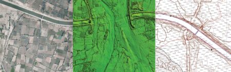
UAV DATA PROCESSING
Standard Outputs:
- UAV Raw Image Processing
- Ortho Mosaic
- GCP based reports
- DSM
- DTM
- Point Cloud
- 3D Mesh
- Contour
Advance outputs:
- Feature Extraction
- Base Map Preparation
- Digitization
- Superimposition of Layouts
- L-section and X- Section generation at any interval
- ROW Analysis
- Cut Fill analysis
- Benching Volume
- Tin Modelling
- Grid Elevation Models
-
-50%

www.geocloud.work is a SaaS platform for any 3rd party desktop software and a Marketplace connecting Employers and Contractors.
₹41.35geocloud.work enables you to work online with a variety of software products – Metashape (Agisoft), 3Dsurvey, CATALYST (PCI Geomatics), Photomod (Racurs), Topocad, Hydromagic, nanoCAD, progeCAD, QGIS, Panorama GIS, Cloud Compare and much more.
Price is per hour.
Open Source Drone Software Solutions
For any drone enthusiast, your go-to resource for the best open source drone software solutions is Index Drone. We understand the importance of having reliable and customizable drone software platform to enhance the capabilities of your equipment, and we’re here to provide you with a curated selection of top-notch open source drone solutions india. Take your drone’s performance to new heights with these exceptional software choices with the best software.
One of our most popular drone software is PX4, Built on an open source ecosystem, this is a flexible and scalable flight control software for drones. It provides precise control, advanced flight modes, and extensive sensor support. PX4 offers an intuitive development environment that has autonomous mode, allowing users to customize and extend its capabilities to meet their specific needs. Whether you have to keep it autopilot or would go for manual operations, this is equipped with loc8 and ai, It is ideal for construction, mapping, racing, public, safety, stocks or any commercial purpose.
At Index Drone, we’re dedicated to helping you make the most of your drone’s potential. Find out more about drone software for surveying here!