Description
Service Type – Generate Orthophoto
Payment Mode Offline/Online
Service Mode – Onsite
Type of Technology – Using By Drone

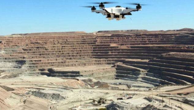
Unmanned aerial photogrammetric survey is the use of unmanned aerial vehicles (UAVs) to take photos for use in photogrammetry, the science of making measurements from photographs. Instruments manufactured for UAVs could be mounted on unmanned flying platforms of various sizes and types, such as octocopters. These machines are suitable for the full geodetic survey of a study site by creating a point cloud of measurements of nearly homogeneous quality and accuracy. These detailed point clouds (of various types of data) could be used in line with orthophotos etc. to obtain a complex data system representing the study site.
Similarly to manned aerial surveys, UAVs are suitable to acquire three-dimensional digital models and orthophoto mosaics for a certain area.


Service Type – Generate Orthophoto
Payment Mode Offline/Online
Service Mode – Onsite
Type of Technology – Using By Drone
| Settings | Aerial Photogrammetry Service remove | Drone UAV Survey remove | Aerial Contours remove | 3D Mapping Drone Service remove | Topographic Land Surveying Drone Services remove | 3D Mining Drone Mapping Service remove |
|---|---|---|---|---|---|---|
| Image |  |  |  |  | |  |
| SKU | ||||||
| Rating | ||||||
| Price | ||||||
| Stock | ||||||
| Availability | ||||||
| Add to cart | ||||||
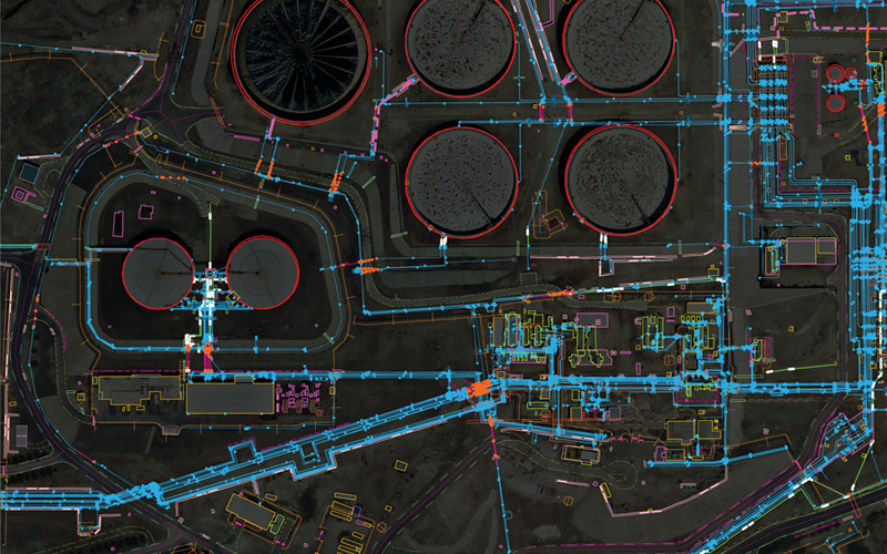
| Description | Unmanned aerial photogrammetric survey is the use of unmanned aerial vehicles (UAVs) to take photos for use in photogrammetry, the science of making measurements from photographs. Instruments manufactured for UAVs could be mounted on unmanned flying platforms of various sizes and types, such as octocopters. These machines are suitable for the full geodetic survey of a study site by creating a point cloud of measurements of nearly homogeneous quality and accuracy. These detailed point clouds (of various types of data) could be used in line with orthophotos etc. to obtain a complex data system representing the study site. Similarly to manned aerial surveys, UAVs are suitable to acquire three-dimensional digital models and orthophoto mosaics for a certain area. | Our organization is offering an assorted range of UAV Survey. We are working dedicatedly to catering to the requirement of the client. Apart from this, our professionals make honest efforts to provide this survey service within the assured set of time. | Surveying India specializes in Aerial Contours. Contour lines are generated by connecting all the points of similar elevation together. These lines are drawn on a plan of a particular terrain to understand the nature of surface, identify cut fill volume, study water flow characteristics, estimate valley depth and steepness. Contour lines form a smooth curve of same elevation points. Contour lines are also called as isohypse, isoline, isopleth, or isarithm. | We are one of the foremost firms of 3D Mapping Service. These services are enormously well-liked in the market for their nominal rates and consistency. | Topographic Land Surveying Drone Services. | 3D Mining Drone Mapping Service. |
| Content | Service Type - Generate Orthophoto Payment Mode Offline/Online Service Mode - Onsite Type of Technology - Using By Drone | Type - Site Service Mode - Offline | Scope Of Survey - All Usage/Application - AutoCAD Type Of Services - Visual Surveying Method - By Drone Service Location - PAN India Service Mode - Offline Service Type - 3D Mapping Drone | Services Include - 3D and 2D Mapping Usage/Application - AutoCAD and Global Mapper Service Mode - Offline Measurement Type - Acre Surveying Method - By Drone Service Type - Topographic Land Surveying Drone Service Location - PAN India | Usage/Application - AutoCAD and Global Mapper Surveying Method - By Drone Service Location - PAN India Service Mode - Offline | |
| Weight | ||||||
| Dimensions | N/A | N/A | N/A | N/A | N/A | N/A |
| Additional information |