-

*Arial Mapping Solutions
Drogo is equipped with best-in-class sensors and cameras, which capture high-quality data, even in low light conditions. Our drones are highly maneuverable, which allows them to fly at low altitudes and capture detailed imagery of the ground. We also use advanced GPS and mapping software, which ensures that our data is highly accurate and precise.
Contact us to and avail a Free consultation NOW!
Stay connected with us
https://linktr.ee/drogodrones -
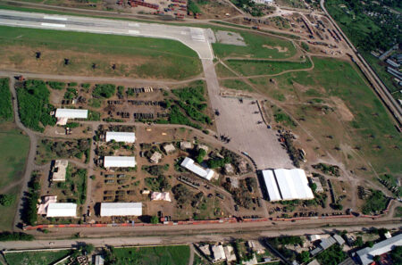
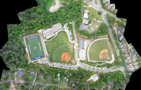
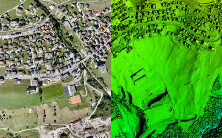
2D/3D MAPPING
2D and 3D mapping can be utilized in the administration of Building or Structures, in Agriculture, in Forest Service, in Mining Industries, Land Soil Development, in Pollution Control, in Flood Management, in Planning Presentation and so on.
-
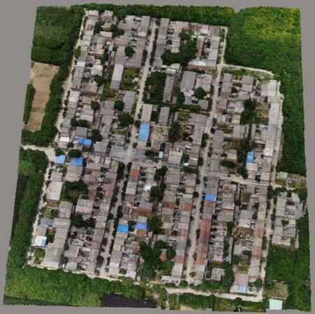
3D Mapping Drone Service
We are one of the foremost firms of 3D Mapping Service. These services are enormously well-liked in the market for their nominal rates and consistency.
-
-
3D Modeling Survey
3D scanning is the process of analyzing a real-world object or environment to collect data on its shape and possibly its appearance (e.g. color). The collected data can then be used to construct digital 3D models.
A 3D scanner can be based on many different technologies, each with its own limitations, advantages and costs. Many limitations in the kind of objects that can be digitised are still present. For example, optical technology may encounter many difficulties with dark, shiny, reflective or transparent objects. For example, industrial computed tomography scanning, structured-light 3D scanners, LiDAR and Time Of Flight 3D Scanners can be used to construct digital 3D models, without destructive testing.
-
Acre 3d And 2d Mapping
With the assistance of our enormously competent land diligent team members, we are involved in offering Drone Survey Service. These interior design work services can be offered as per client preferences. Apart from this, we are rendering these services with the help of the latest technology-based resources
-
Aerial Contours
Surveying India specializes in Aerial Contours. Contour lines are generated by connecting all the points of similar elevation together. These lines are drawn on a plan of a particular terrain to understand the nature of surface, identify cut fill volume, study water flow characteristics, estimate valley depth and steepness. Contour lines form a smooth curve of same elevation points. Contour lines are also called as isohypse, isoline, isopleth, or isarithm.
-

Aerial Drone Mapping Survey Service
We strives to provide visible Aerial Drone Surveying/Mapping administrations all through India. With precise knowledge of the relevant field, we are instrumental in offering a comprehensive range of Aerial Mapping Service. We work for DJI Aerial Mapping Service as per the clients need. Also, offered services are famous for high flexibility, and quality assured.
-

Aerial Drone Survey Service
Backed by years of experience in this domain, we have been able to offer the finest collection of Aerial Drone Survey. These services are admired for quality assurance and client focus approach. Apartfrom this, our team members remain in close contact with patrons to determine their requirements and render these survey services accordingly.
-

Aerial Imaging
We specializes in capturing aerial imagery at various heights using unmanned aerial aircrafts, also known as Drone, UAV or UAS, equipped with high-resolution cameras and multi-axial gimbal. This technology enables us to operate in a fast, flexible and cost saving manner. Since we fly below cloud cover we can operate on many more days compared to manned aerial photography missions. Flying at low altitudes yields unique and ultra-sharp images in which every detail is visible.
-
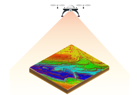
Aerial LiDAR Surveying and Mapping
Lidar data is an accurate and effective method for creating three-dimensional topographical aerial maps and highly accurate aerial surveys of both surface terrain elements and man-made structures. Mavic Aviation has developed a custom aerial Lidar Mapping and surveying production workflow which adheres to the specifications outlined in Base Specification Guidelines.
-
-20%
Aerial Mapping
₹800.00Unlock the Power of Precision with Dronimagination’s Aerial Mapping and Survey Solutions!
At Dronimagination Pvt Ltd, we’re proud to introduce our cutting-edge aerial mapping and survey services powered by state-of-the-art drone technology. We understand the vital role accurate spatial data plays in decision-making for a wide range of industries, from agriculture and construction to urban planning and environmental management. Our specialized drone-based solutions offer a transformative way to acquire, analyze, and utilize high-resolution data for your projects.
Key Benefits:
High Precision Data: Our drones are equipped with advanced sensors and cameras that capture highly accurate, geo-referenced data, ensuring precise mapping and survey results.
Efficiency: Traditional ground-based surveying can be time-consuming and labor-intensive. With our drone services, we significantly reduce project timelines and costs while increasing efficiency.
Versatility: Whether you need topographic maps, 3D models, orthomosaics, or thermal imaging, our drones can be tailored to your specific project requirements.
Safety: Dronimagination’s drone-based services minimize the need for human presence in potentially hazardous environments, enhancing safety for both your team and the environment.
Environmental Impact: By utilizing drones, we reduce our carbon footprint compared to traditional survey methods, aligning with sustainable and eco-friendly practices.
Custom Solutions: We work closely with our clients to understand their unique needs and tailor our services to deliver actionable insights for informed decision-making.
Industries We Serve:
Agriculture: Optimize crop management, monitor soil health, and enhance yield predictions with our precision agriculture solutions.
Construction: Streamline site analysis, progress monitoring, and site planning to keep your construction projects on track.
Environmental Management: Monitor and protect fragile ecosystems with our environmental surveying services, tracking changes and promoting conservation efforts.
Urban Planning: Create detailed 3D models of urban areas to aid in infrastructure development, land-use planning, and smart city initiatives.
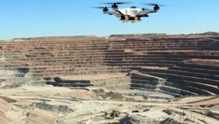
Mining and Exploration: Improve mineral exploration and extraction processes with accurate geological data and mine site analysis.
Infrastructure Inspection: Perform remote inspections of critical infrastructure such as bridges, power lines, and pipelines, ensuring safety and maintenance.
Emergency Response: Rapidly assess disaster-stricken areas for search and rescue operations or damage assessment.
With Dronimagination’s aerial mapping and survey solutions, you can harness the power of precise, actionable data to make informed decisions, enhance productivity, and drive the success of your projects. Join us in revolutionizing the way you gather information, and experience the future of aerial mapping and surveying today.
Contact to learn more about how our drone-based services can transform your industry and make your projects soar above the competition.
-
Aerial Mapping Service
Through regular improvement, we are offering an exclusive collection of Aerial Mapping Service. Our highly skilledprofessionals render this offered mapping service on well-defined parameters. Offered array of mapping services is rendered using best grade inputs. -

Aerial Photogrammetry Service
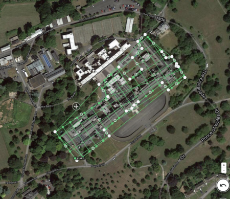
Unmanned aerial photogrammetric survey is the use of unmanned aerial vehicles (UAVs) to take photos for use in photogrammetry, the science of making measurements from photographs. Instruments manufactured for UAVs could be mounted on unmanned flying platforms of various sizes and types, such as octocopters. These machines are suitable for the full geodetic survey of a study site by creating a point cloud of measurements of nearly homogeneous quality and accuracy. These detailed point clouds (of various types of data) could be used in line with orthophotos etc. to obtain a complex data system representing the study site.
Similarly to manned aerial surveys, UAVs are suitable to acquire three-dimensional digital models and orthophoto mosaics for a certain area.
-

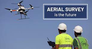
Aerial Survey Service
Technological advances in both video camera equipment and RC (remote control) equipment allow Surveying India to capture cinema quality, full motion imagery. Using state or the art equipment we are able to go where zip lines, cables, camera booms are not, still retaining the integrity of the shot by capturing complicated and challenging footage. Conversely, to previous methods of filmmaking, our set-up and take-down time is quick and efficient. All our projects were met with a great satisfaction among our customers.
-
Aerial Surveying & Mapping
Complete Aerial Survey & Mapping
Gis Data Processing & Analysis
Best Drones Surveying & GIS Mapping Company in India
Drone technology has revolutionized the field of mapping and surveying services, providing efficient and accurate data collection capabilities. Drones, also known as unmanned aerial vehicles (UAVs), offer numerous advantages over traditional surveying methods, making them increasingly popular in the industry. Drone survey in India is getting highly popular given its advanced imaging technologies. Index Drone is a top trusted drone surveying company in India. Using the best drone software for mapping, can capture aerial imagery and collect data from above, providing a comprehensive view of the surveyed area.
The gis mapping drone capture high-resolution topographical imagery and collect accurate geospatial data. Select the best drone for gis mapping with the high-end picks from Index Drone and get the finest aerial survey in India. Gis mapping with drones are easy to deploy, requiring minimal setup time compared to traditional surveying equipment. This makes them particularly useful for time-sensitive and cost effective projects or areas that are difficult to access. By gis mapping using drones, surveyors can reduce the need for manual inspections in hazardous or hard-to-reach locations. This helps improve safety conditions for surveying personnel.
Drone survey India have become invaluable for maps and surveying services, providing accurate data collection, efficient coverage, and enhanced safety. As the technology continues to advance, drones are likely to play an increasingly significant role in various industries that rely on geospatial data.